



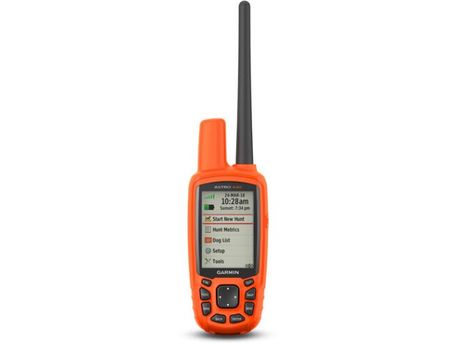
Alpha 50 Dog Tracking Handheld Handheld only

This product is archived (discontinued) and is shown for information only.

 4.8
861 reviews
GPS Eesti on Google


Alpha 50 GPS device with GLONASS support for tracking dogs.
- Track up to 20 dogs at once using T5/DC50 collars within a range of up to 14.4 km (line of sight), or up to 6.5 km using T5 mini collars.
- 2.5-second position updates let you see your running dog's movements quickly and accurately.
- GLONASS support provides better GPS signal strength, even in the toughest conditions.
- Records the dogs' speed and distance travelled.
- Recreation Map of Europe v4 preloaded in internal memory
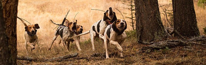
An invaluable tool in the field, the Alpha 50 helps you get the most out of your hunt. This simple touchscreen device lets you track up to 20 dogs from up to 14.4 km away, with 2.5-second accuracy.
Track your dog from afar
The T5 sends your dog's location to your device every 2.5 seconds, so you can see the dog's current location and a track log of where it has been, right on the map. Go to the dog tracking page and check the compass to see which direction your dog is in and whether it is running, sitting or pointing game. You get an audible alert when the dog has reached a certain point.
Each dog's location can be seen on the map, and you can set the device to zoom the map automatically so that all dogs are always visible. In addition, dogs that are too far away to fit on the map are shown at the edge of the screen with small arrows pointing in their direction. You can choose how long the device displays a dog's track log, or turn it off altogether.
!!T5 and T5 mini collars work with both the Astro 320 and Alpha devices!!
If a dog's T5 collar is paired with an Astro 320, the collar will no longer work with Alpha handhelds! And vice versa, i.e. the collar cannot be used with both the Astro 320 and Alpha devices at the same time.
The Alpha 50 also supports DC 50 collars (DC 50 collar software update required), but like T5 collars, DC50 collars cannot be used with both Astro and Alpha devices at the same time.
To track with Alpha 50, power on the DC 50 and keep holding the power button. The DC 50 will periodically beep. Go to the dog list and choose Add Dog->Near Collar->Yes. The handheld should detect the DC 50 and pair to it and the DC 50 will switch to Alpha 50 mode.
Add maps
Adding maps from Garmin's selection preloaded on microSD cards is easy – road maps and topographic maps are available. Conveniently add City Navigator NT maps for on-road navigation. The memory card slot sits behind the waterproof battery cover, so you don't have to worry about it getting wet. You can also load maps you or someone else created in Google Earth onto the Alpha 50 (Garmin Custom Maps).
Count your game
Once you have reached the game, mark its location with Alpha's Covey Counter™, a special waypoint that shows the game's location, the date found and elevation above sea level, as well as the number of birds bagged. Alpha also lets you save other important places such as “Truck” (vehicle location) and “Lodge” (shelter, home, campsite). You can also save locations of feeding sites and other hunting-related places.
Plan your next hunt
Take control and plan your next hunt with BaseCamp software, which lets you view and organise maps, waypoints, routes and tracks. This free trip-planning software even lets you create Garmin Adventures that you can share with friends, family or fellow adventurers. BaseCamp displays topographic map data in 2-D or 3-D on your computer screen, including contour lines and elevation profiles. You can also transfer high-quality raster map images to your device when you purchase BirdsEye Select or BirdsEye Satellite Imagery.
Turn your computer into a base station
Load BaseCamp onto your laptop to turn it into a base station for tracking dogs (up to 20 T5 or T5 mini dog collars). View real-time GPS information on a larger screen, making it ideal for canine search and rescue teams. And because it uses GPS/GLONASS, you can track information securely and without problems, even when internet and mobile phone service is unavailable.
Share wirelessly
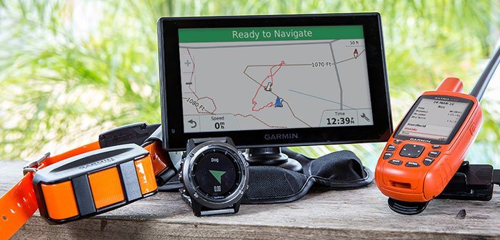
With the Alpha 50, you can share your waypoints, tracks, routes and geocaches wirelessly with users of other compatible Garmin GPS devices. Now you can send your favourite hike to a friend to enjoy or a geocache for them to discover. Sharing data is easy. To send your information to a similar device, just touch the “Send” button. The Alpha 50 can also relay your dogs' locations in real time to the 7" screen of the Garmin DriveTrack 70LMT or to the fenix 3 watch on your wrist.
Rely on your device
The Alpha 50 is a true outdoor-optimised GPS device, with every feature designed to work reliably in even the harshest and most challenging environments. For the best readability in all conditions, the Alpha 50 has a 2.6" sunlight-readable colour display, and its simple user interface makes it easy to use with gloves, even in cold or wet environments. For convenience and maximum freedom, the dual battery system lets you use rechargeable batteries or standard AA batteries. A fully charged Alpha 50 lasts up to 20 hours, giving you plenty of time for unexpected adventures and long hunts.
Read more about VHF range here: VHF range
NB! Garmin dog tracking devices work only in their intended regions; US devices do not work in Europe and vice versa. Be sure to also comply with the radio communication laws and licence requirements of the respective country.
Key features
| Dimensions, W x H x D | 6.1 x 16.0 x 3.6 cm |
| Display size, W x H | 3.6 x 5.5 cm; 2.6" diagonal (6.6 cm) |
| Display resolution, W x H | 160 x 240 pixels |
| Display type | anti-glare, 65K colour TFT |
| Weight | 260.1 g with batteries |
| Battery | 2 AA batteries (not included); NiMH or lithium recommended |
| Battery life | 20 hours |
| Water rating | Yes (IPX7) |
| GLONASS | Yes |
| 3-axis compass | Yes |
| Barometric altimeter | Yes |
| Computer interface | USB |
Maps & memory
| Basemap | Yes |
| Ability to add maps | Yes |
| Memory card slot | Yes, microSD card |
| Internal memory | Yes (1.7 GB) |
| Waypoints/favourites/locations | 2000 |
| Routes | 200 |
| Track log | 10,000 points, 200 saved tracks |
Features
| Estonian-language menu | Yes |
| Russian-language menu | Yes |
| Custom POIs (ability to add extra points of interest: speed cameras, hotels, etc.) | Yes |
| Automatic routing on roads | Yes (with optional maps) |
| Hunt/fish calendar | Yes |
| Sun and moon information | Yes |
| Area calculation | Yes |
| Tide tables | Yes |
| Unit-to-unit transfer (share data wirelessly with similar units) | Yes |
| L-EST coordinate support | Yes |
| Garmin Connect™ compatible | Yes |
| Custom maps compatible | Yes |
Other information
| Frequency | VHF, MURS; 155.450MHz - 155.475MHz; 2W (ERP) |
| Range | T5/DC50: up to 14.4 kilometres (line of sight) T5 mini: up to 6.4 kilometres (line of sight) More information here: VHF coverage |
| Additional | Tracks up to 20 dogs at once |
| Vibration mode | Yes |
Handheld only
- Alpha 50
- Recreation Map of Europe v4 preloaded in internal memory
- Belt clip
- Long-range antenna
- USB cable
+ T5X and Regio Topo Bundle
- Alpha 50
- Recreation Map of Europe v4 preloaded in internal memory
- Belt clip
- Long-range antenna
- USB cable
- T 5X dog device
- 1″ collar strap
- 18.5″ standard antenna
- 22.5″ extended-range antenna
- Charging cable
- AC adapter
- Vehicle power cable for in-car charging
- Regio Estonia Topo map on memory card
